Faversham Life
Faversham Life
Words Justin Croft Photographs Courtesy of Faversham Town Council; Lisa Valder
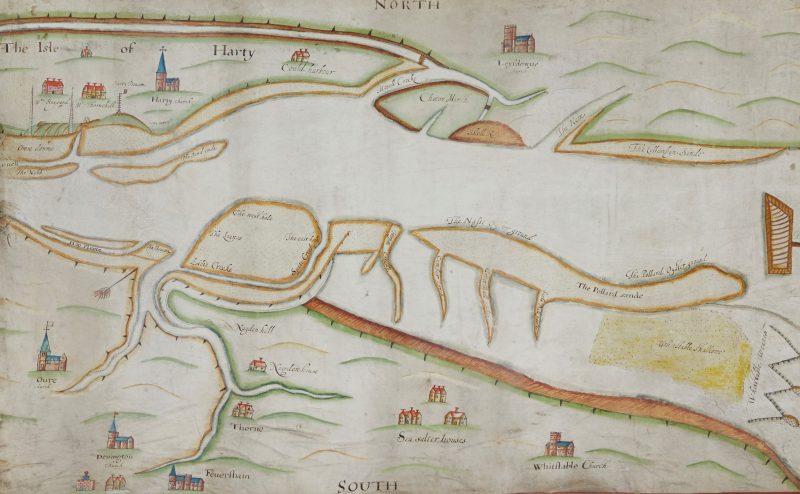
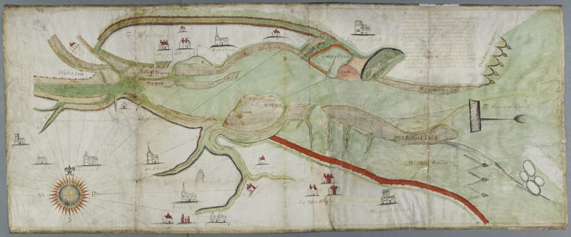
Faversham and the Swale in the early 17th century.
Our tidal creek, leading out into the Swale and Thames estuaries, is a primary reason for the town’s very existence. If we look at the map and think of water as a highway rather than a barrier, then we can see Faversham’s pre-eminent position in historical trade between Kent and the city of London, and between England and the Continent. Lately though the Creek has featured repeatedly in local planning and environmental news. The Cleve Hill solar park is likely to cover the land along its north-eastern banks at Nagden. Proposals have been made to build housing on land around Abbey Fields, while other plans were recently considered for the Creek’s southern tip at Ordnance Wharf. New houses go up around Standard Quay and residents watch, bemused, as flood water from recent surge tides comes up over the quay covering the roads around the Brents bridge. The bridge itself, and its long-delayed replacement, is a source of debate and local dismay. On a happier note the Faversham Rowing Club is making good use of the upper basin and it has been wonderful to see oars and sails on the water already this year. Seals too have been enjoying the fine weather, basking on the mud at Hollow Shore.
One of Faversham’s Oyster Fishery Maps
Given all this attention, it’s a timely moment to look at one of Faversham’s lesser-known historical treasures, a series of unique 17th century maps of the Creek soon to go on permanent display at the Town Council Offices in the Market Place. Dating from the year 1608 (or thereabouts) there are three maps, showing the same area, drawn with pen and ink on animal-skin parchment. Each map is just over a metre wide. All three are finished slightly differently with place names and charming thumbnail drawings of landmarks, especially churches. They survive in exceptional condition and the colouring (watercolour) is in most cases still fresh and vibrant. The shades of green and red are especially lovely, as is the bright sky blue used for some of the rooves.
These were made at the time of an enquiry into fishing rights in the Creek and the Swale in general, so there is some superb detail of the various sand and shingle banks in the channel between Faversham and Sheppey, together with truly fascinating details such as the fish traps or ‘weares’ east of Whitstable and the ‘Snowt Weares’ on the easterly coast of Sheppey. Notice the beacons at the Creek’s mouth at Oare (Harty Ferry) and over the water at Harty itself. Such beacons — fires lit in a brazier mounted at the top of a pole — not only warned ships of coastal hazards but were also a crucial part of England’s defences. A system of beacons in Kent could transmit signals from the coast to London in a matter of minutes in times of national danger.
A beacon at the mouth of Faversham Creek, Oare church and Nagden
The simplified and naïve representations of buildings and undulations of the land doesn’t detract from the sophistication and accuracy of the mapping itself. It’s interesting to compare them with later maps and to think about how they were made. The captions tell us that the survey was made with a ‘perambulation’ — literally a ‘beating of the bounds’ by land and water reinforcing existing local knowledge and customs concerning the boundaries of the Faversham fisheries. While this would have established the bounds, it seems likely that the maps were produced by local surveyors using instruments such as a compass and plane table, then commonly used to transfer an image of land onto a flat surface.
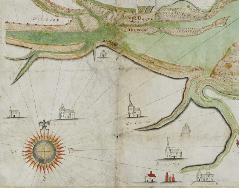
A compass rose, with Buckland, Luddenham, Oare, Davington and Faversham churches
One of the maps incudes a rather spectacular compass rose at its bottom left with radiating points and lines. It is more than just decorative and suggests how the land was physically surveyed. Its position is interesting – placed South of Luddenham and Oare on some of the highest ground in the area. If you stand today anywhere around this spot (on Lower Road, near Four Oaks Farm) the view is obscured by thick coppice wood, but through the trees it is clear that this was always among the best views in the area, with sight lines across the water to Sheppey, over Faversham to Boughton Hill and far out into the Thames Estuary beyond Whitstable. It’s quite possible the maps were surveyed from this point.
These are remarkable survivals and we are lucky to have them. Two seem to have been tucked away at Tassell’s Solicitors, and they have kindly made them available for exhibition, while the third was kept in the tenebrous light of the old Mayor’s Parlour at the Alexander Centre. This relative obscurity accounts for their excellent condition, and so exhibiting them now comes with certain important responsibilities.
Faversham resident Sarah Stanley, who is Service Manager at Kent Archives in Maidstone, has been responsible for preparatory conservation. While the maps are surprisingly tough and durable (parchment is far stronger than paper) they required some archival preparation so they can be displayed in the exhibition cases. Sarah has carefully removed later mounts (which might contain unstable materials detrimental to the maps) and has gently cleaned layers of surface pollutants (dust and smoke from the atmosphere) to ensure the parchment remains stable for the future.
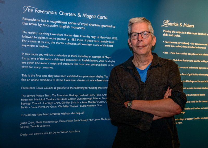
Meanwhile, Darius Wilson, who has long experience of supplying museum displays for the likes of English Heritage and the National Trust, has devised a purpose-built case to allow the two best maps to be shown adjacent to each other. Apart from security, lighting is an important consideration. Colours of the type found on the maps are fragile and precious, so must be subjected to an absolute minimum of lighting. The lights will only be activated while visitors are in the room and then only to an intensity of 50 lux (a lux is equivalent to one lumen of light per square metre). All the wonderful detail of the maps will be clearly visible but will be preserved for generations to come by these careful conservation decisions.
Darius Wilson, responsible for the design and construction of the forthcoming exhibition in Faversham.
The maps will go on display from 26 May as part of the The Faversham Charters & Magna Carta exhibition. While the charters are the jewel in the crown among Faversham’s archives, the Oyster Fishery maps will surely captivate us all and encourage us to continue our own perambulations of our precious Creek.
Further reading (both titles available at Faversham Library).
The Faversham Oyster Fishery through eleven Centuries, Duncan Harington and Patricia Hyde (2002).
The Historical Development of the Port of Faversham 1580-1780, Paul Wilkinson (2006), with the text online here.